

Surface processes with FastScape
LaMEM can couple its free surface to FastScape, a landscape-evolution model that computes river incision, hillslope diffusion, sediment transport and deposition on the surface grid. Instead of the built-in erosion/sedimentation, the topography is then evolved by FastScape every time step, and the deposited sediment is turned into a LaMEM phase of your choice.
This needs a LaMEM binary that was compiled with FastScape, which is the case for LaMEM_jll 3.3.0 or newer (it ships Fastscapelib_jll). You can check this with
julia> using LaMEM
julia> println(readchomp(`$(LaMEM.LaMEM_jll.LaMEM()) -fastscape_info`))
Setting it up from Julia
FastScape is switched on with surf_mode=2 in the FreeSurface and configured with a FastScape structure:
julia> using LaMEM, GeophysicalModelGenerator
julia> model = Model(Grid(nel=(32,8,16), x=[-50,50], y=[-10,10], z=[-50,10]),
                     Scaling(GEO_units(stress=1000MPa, viscosity=1e20Pa*s)),
                     Time(dt=1e-3, dt_min=1e-5, dt_max=1e-2, nstep_max=3, nstep_out=1, time_end=1),
                     FreeSurface(surf_use=1, surf_level=0.0, surf_air_phase=0, surf_mode=2,
                                 FastScape=FastScape(sed_phases=2, max_fs_dt=1e-3, fs_refine=2,
                                                     topo_boundary="1111", vel_boundary="0000")),
                     Output(out_dir="fastscape_example"))

julia> add_box!(model; xlim=(-50, 50), ylim=(-10, 10), zlim=(0, 10),  phase=ConstantPhase(0), T=nothing)   # air
julia> add_box!(model; xlim=(-50, 50), ylim=(-10, 10), zlim=(-50, 0), phase=ConstantPhase(1), T=nothing)   # crust
julia> add_box!(model; xlim=(-10, 10), ylim=(-10, 10), zlim=(-50, 2), phase=ConstantPhase(1), T=nothing)   # a plateau

julia> add_phase!(model, Phase(ID=0, Name="Air",      eta=1e19, rho=50),
                         Phase(ID=1, Name="crust",    eta=1e21, rho=2700),
                         Phase(ID=2, Name="sediment", eta=1e20, rho=2500))

julia> run_lamem(model, 1, logfile="fastscape")
The FastScape surface is written next to the other output as *_fs.pvd.
Some points to keep in mind:
sed_phasesis the phase ID given to newly deposited sediment. It has to exist in the model.If a LaMEM step is longer than
max_fs_dt, it is split into several FastScape substeps.topo_boundaryandvel_boundaryhave one digit per boundary, in the order bottom (y-min), right (x-max), top (y-max), left (x-min). Fortopo_boundary,1means fixed height (sediment can leave the model) and0a reflective boundary. Forvel_boundary,1means zero velocity, and0that the velocity transferred from LaMEM is kept.The marine parameters (
sealevel,poroSilt, ...) are only written ifset_marine=1.For a 2D LaMEM model, use
fs2D=1: the 1D surface is then extended in the second horizontal direction overextendedRange, withextendedNodespoints.
All parameters, with their defaults, are listed in the docstring of FastScape.
Using an existing input file
A parameter file that already has a <FastScapeStart> block can be run as it is, as with any other LaMEM input file:
julia> run_lamem("Collision_FastScape.dat", 4)Example: subduction in 2D and 3D
example_scripts/Subduction_FastScape.jl sets up a subduction zone with FastScape, as a 2D cross-section or as a 3D model. It follows the subduction model of the manuscript (input files on Zenodo): an oceanic plate is pushed towards a continental plate at 5 cm/yr by a moving block (BCBlock) and subducts along a weak zone that dips at 30°, while FastScape erodes the topography that builds up and deposits the sediment as phase 8. The 3D model has an oceanic plateau on the subducting plate, which makes the subduction zone vary along strike.
julia> include("example_scripts/Subduction_FastScape.jl")
julia> model = subduction_fastscape_model(ndim=2, nel=(192,48))      # a 2D cross-section
julia> view_model(model)                                             # check the setup (needs a Makie backend)
julia> run_lamem(model, 4, logfile="subduction")
For 3D, use ndim=3 and nel=(nx,ny,nz):
julia> model = subduction_fastscape_model(ndim=3, nel=(192,48,48))
julia> run_lamem(model, 8, logfile="subduction")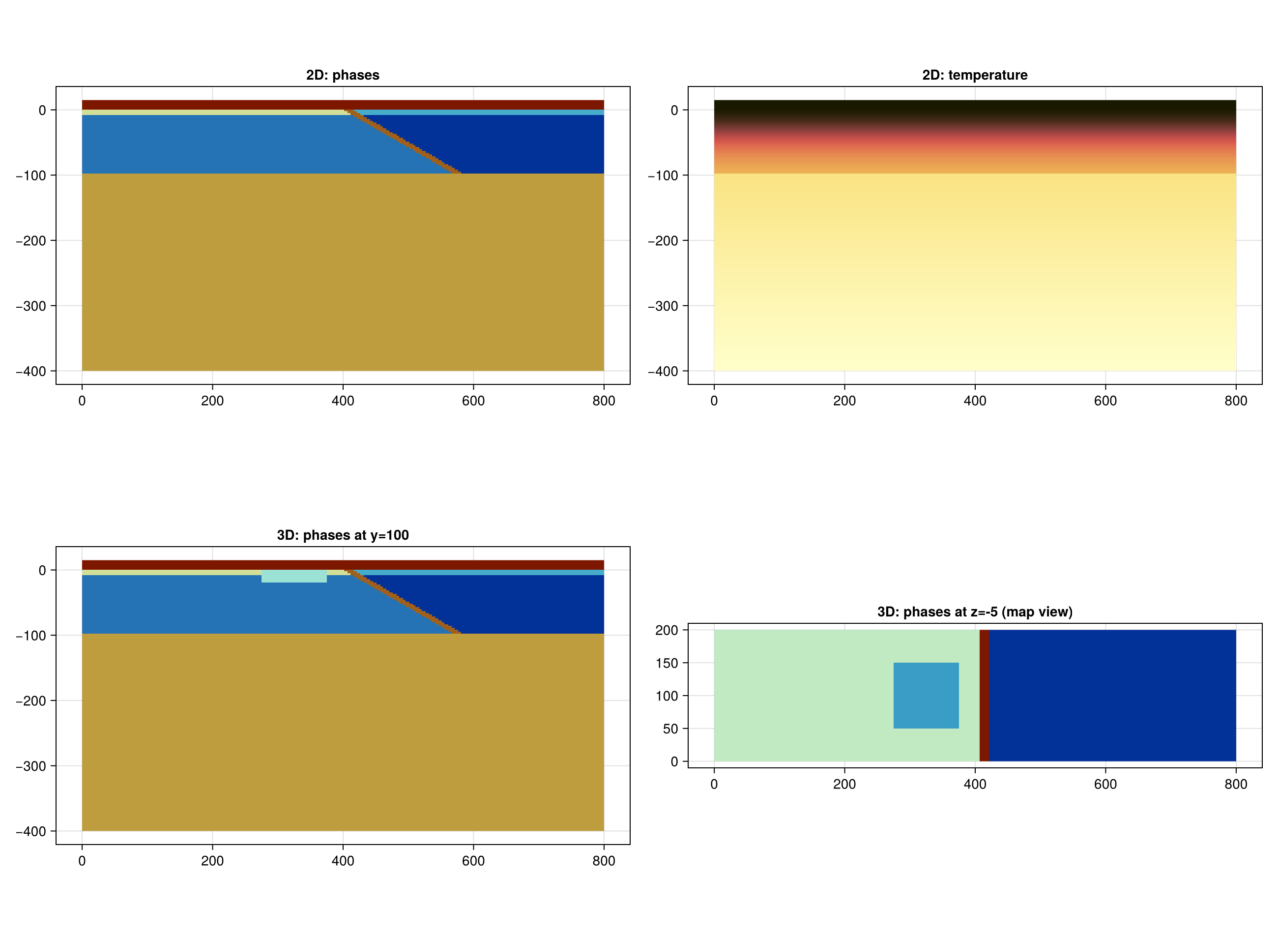
Top: the 2D setup, with the phases and the temperature. Bottom: the 3D setup, as a section through the middle and in map view at z = -5 km, where the oceanic plateau is the square on the subducting plate.
In 2D the surface of LaMEM is a line, so the FastScape domain is extended along strike (fs2D=1, over 100 km). The fs_refine keyword sets how much finer the FastScape grid is than the LaMEM surface grid.
Differences with the GMD manuscript, which ran the 3D model with 384×96×96 elements on 256 cores:
the default resolutions here are much lower, and
fs_refineis 2 instead of 6, so that the models run on a laptop;the temperature of the plates uses a half-space cooling profile of 70 Myr everywhere, without the younger part along the left boundary of the manuscript's model;
the manuscript's coupling of LaMEM 3.0.1 and a modified FastScape is not identical to the FastScape that is built into LaMEM, so the results are not expected to be the same.